
Keyword
Earth Science | Oceans | Coastal Processes
4 record(s)
Type of resources
Topics
Keywords
Contact for the resource
Provided by
Formats
Update frequencies
Status
draft
-
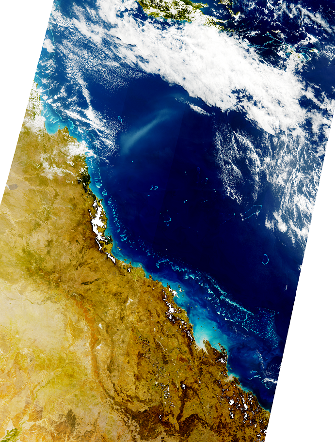
Sentinel-3 OLCI reduced resolution (approximately 1000m-pixel size) daily Level 1B true-colour quicklooks produced by CSIRO under eReefs Phase 5 delivered in GeoTIFF format.
-
KSN Project 2.2.2 provides key information on the oceanographic and biological forcing associated with nutrient supply that determines the near-shore productivity of the Kimberley region, and links these with higher trophic levels. Key objectives of the research were - To make new estimates of pelagic primary productivity, identifying the key physical and community processes driving production in the region. - To better describe the phytoplankton and zooplankton communities in coastal waters of the Kimberley, to determine the trophic linkages within these communities and to identify the key factors controlling pelagic secondary productivity. - To integrate these parameters into an extensible biogeochemical modelling framework, allowing predictive linkages between physical and biological processes in the region. This metadata records specifically relates to modelling aspects of the project completed by CSIRO. The data originates from a number of model simulations conducted between 3/1/2010 to 21/12/2010. All field data are held at Pawsey and RV Southern Surveyor and RV Solander.
-
This record describes multibeam echosounder data collected on Bluefin voyage BF2018_V01, 'Hydrographic survey of the Petuna Aquaculture Sites in SW Bass Strait' which departed Stanley, Tasmania on the 27th June 2018 and returned to Beauty Point, Tasmania on the 4th July 2018. This survey was a part of a broader mapping campaign that involved a survey of the Boags Commonwealth Marine Reserve. The Kongsberg EM2040c multibeam echosounder was used to acquire seafloor bathymetry and backscatter information and watercolumn backscatter at the Boags Marine Reserve in the Bass Strait. The EM2040c provides a 1.3° by 1.3° transmit and receive angular resolution respectively. The echosounder's nominal frequency was 300 kHz and was operated in dual swath mode. Data are stored in *.all raw format for bathymetry and backscatter and *.wcd format for watercolumn backscatter at CSIRO. There are 269 files totalling 73.6 GB of raw .all data, and 269 files totalling 0.64Tb of raw .wcd in this combined campaign dataset. Sound velocity profiles were applied to this data during data acquisition. Bathymetry data contained in *.all format are corrected for motion and position. Tide corrections were not applied to the final processed dataset. Instead the data was mapped to the ellipsoid (GPS Height) and thereafter reduced to AHD (Australian Height Datum) using the AusGeoid09 model. Processed data has had outliers removed. Processed line data are available in *.gsf and ascii format, and processed bathymetry and backscatter grids in geotiff format. Additional information regarding this dataset, including further information on processing streams, is contained in the GSM data acquisition and processing reports. Additional data products may be available on request.
-
The Kimberley region is vast, remote and difficult and expensive to access and carry out field work in. Remote sensing technologies can provide cost effective methods to gather historical and baseline data at synoptic scales as well as near-real-time observations from metre to kilometre resolution. The Kimberley Node Project 1.4 focused on monitoring turbidity with reference to its impact on the water column and substrate light environment. The projects objectives were to analyse uncertainties of remotely sensed turbidity products by comparison of different algorithms and different resolution products with each other and with archived in situ data; and to analyse time series of remotely sensed turbidity data to provide first-stage pilot products that may be applicable for future use as marine management tools. In-situ water quality data was obtained from a number of cruises that occurred along the Kimberley coastline including Collier Bay; Walcott Inlet, Outer King Sound, Koolama Bay and Lesueur Islands, Van Diemen Gulf and the Pilbara Coast and used to validate remote sensing products. Data associated with this metadata record relates to in-situ water quality. MODIS satellite data obtained from IMOS has not been stored as part of this record, but can be accessed direct via IMOS (http://www.imos.org.au/).